
A sketch of the future…
As promised in an earlier post, here is a look at just some of the proposed developments that we hope to be creating at Beamish over the next five to eight years or so. Hopefully they will give readers some idea of what is planned.
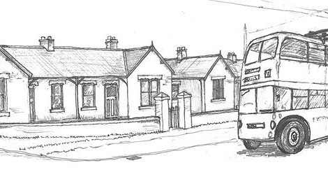
Below: We start with the 1950s urban area – seen here marked in red on our standard map. Also shown is the main development area in the Georgian landscape.

Below: An idea of how the urban area might fit into the existing landscape – I should emphasise the ‘might’ here! Trolleybuses will take a slightly different route into this space, probably looping around the cinema to enable turn backs or lay overs in a number of bus stands. It will also create operational interest. I should note here that buses and trolleybuses will share the duties over the 1950s route, flexing up and down according to demand and leaving the Town – Colliery circular to the replica buses. If we can run to it, I’d like to install a crossover on the tramway on the double track section as it comes off the single line. We can then have a 1950s stop for inner circle trams as well as enabling turn backs for trams on short workings. This might suit 513 for instance. It would also enable the Town street to be used for events or by horse trams, without inhibiting the electric tram service.
There is also some thought to having a miniature railway around the recreation ground, if space permits! I can’t reiterate enough that the detail of these plans will change though! These sketches are the culmination of nearly five years discussion, planning and drawing, and there will be changes, adaptations to new opportunities and amendments to suit the landform and ground conditions.

Below: A close up of the aged miners homes (shown above, to the west of the map), complete with 501, actually running the opposite way to that which it would usually pass by.

Below: Over at Pockerley, the Georgian Coaching Inn dominates the scene. Note also the Blacksmith, Quilters and Potters plus a platform at the east end of the Waggonway. Also of note is the windmill to the north, in the picnic field of Pockerley Old Hall.

Below: A view of the crossroads, with the Coaching Inn to the fore, extending rearwards to provide overnight accommodation. To the right is an assembly room.

Below: This map has appeared on the blog before and has also changed since I drew it! It is basically correct though and shows the intended expansion of the narrow gauge, new mining features and the completion of the standard gauge running line and sidings. This development work will continue on an incremental basis, as has been the case in recent years for this area.


Fascinating. Would it be possible to publish larger versions of the 1950s town plan so that the detail can be more clearly seen? Thanks
Hi Garry – over the next 18 months or so we will publish the detailed plans – as the various press releases state, the initial HLF support is to develop and cost the scheme, with the second round being the funding to build it, so at present we have the ideas and overall scheme as shown here, but detailed plans must wait until we have done a considerable amount of work on the project to fix the exact shape and scope. But in terms of development times for such huge projects, it won’t be that long before we have something to show everyone! Paul
Thanks for posting these, all looks very exciting!
Are the plans for terraced houses, a colliery inn and a coop store in the pit village a source of seperate funding or are they longer term?
Hi John – the Colliery developments, whilst still in our overall development plan, will form part of a future phase of work and are not part of this HLF funded phase – though if someone came forward to fund them then I am sure we would be pleased to hear from them! Paul
I take it when you say Terraced houses you mean Tyneside Flats ? As there has been some talk about these lately in the media.
No, terraced houses in the Pit Village, though a plan for Tyneside flats as an extension of the Town also featured in the overall and much longer development plans. Neither of which are in this phase of development though – something to find funding for at a later date! Paul
Hi ,
I think these plans are fantastic news , and very creative to have a 50’s town built.As a keen transport person I am looking forward to the day the trolleybuses will start running…very exciting . Very much something to look forward too.
I would personaly like to see a Fire and Police station Plus a post office.