
Beamish Museum – 1983
There has been quite a lot of discussion on social media platforms with regard to the railway at Beamish and the route it once took between Rowley Station and the Colliery. The route was never successfully implemented as a passenger line, the curves being sharp, gradients steep and quality of installation indifferent. The proposal for a station at the Colliery end of the route was rejected and the passenger train ride that was operated from Rowley ran over pretty much the same amount of track as it does today. Occasional trains with passengers (as out of hours guests) are known to have traversed the whole length of the line, but it is probable that the number of photos taken of these (this?) occasion, have slightly misled history in terms of how often this occurred. There is certainly evidence of passengers being carried in chaldron waggons over the route as well.
I thought a quick look at this would therefore be of interest, and I’ll re-post this on the social media platform which has shown the most interest in this as well.
Below: This is the museum site in 1983. The view is taken from the north, looking south towards what would become the Entrance and Car park, which occupies the top quarter of the image. At this date, it was an opencast mine, with coal being extracted before the land was made-good and the car park constructed. You can make out the Entrance building to the south of the excavation site.
At this stage the Tramway ran from the Town to Foulbridge , though the route of the extension (that would open in the autumn of 1986) can be seen in the photo – labelled ‘A’ and ‘B’. This was created with a very considerable amount of fill (I believe from demolished terrace rows in Gateshead) to make the embankment clearly visible to the left of the woodland. There is no trace of what would become the route through Birch Wood, which would be developed in the 1990s.
The Town is clearly visible to the bottom of the image (with the Ravensworth Terrace labelled ‘D’) with the railway sidings bottom left (complete with Polytunnel restoration ‘shed’ labelled ‘F’), and Rowley Station bottom right. To the right of this is the visitor car park and old entrance building (E), and slightly above it is the ‘Beamish Begins Here’ exhibition building, located in what is now the Events Field (labelled ‘C’).
The large area of land to the left of the Town is what was known as ‘The Compound’ and formed a large storage area for all manner of objects and buildings. It is now the site of the 1950s area and Front Street.
The railway is clearly visible running on what is now the Tramway formation at the very left hand side of this view, before it swings to the right and heads for the Colliery, below the hillside upon which Pockerley Old Hall is located (then still a working farm). The location of the crossing adjacent to the present site of the Welfare Hall can be seen.
In many ways, it is a great pity that the railway wasn’t created in a more durable and operationally successful manner, as the route between the Colliery and Rowley would have given us an integral transport link, around which the Tramway could still have been woven. But we are where we are, and as we found when relaying the railway at Rowley some years ago, there was considerable work required in bringing the formation as well as the railway itself, up to passenger-carrying standard.

Below: One of the unconventional operations of the 1970s entailed using an adapted chaldron waggon (with a door in the end – think about the access to that one!) behind Coffee Pot No.1 (and presumably, No.18 on occasion too). Continuous brakes were not a consideration of this activity, but it would have been well within the capability of No.1, which is seen here rounding the curve with the hill upon which Pockerley is located in the background, and Birch Wood to the right. This is the location of narrow gauge railway at Pockerley, the site of the bus/tram stops being in the left background of this view. By comparing this view with that above, it is where that track curves to the right, below the almost square of woodland (Birch Wood), with Pockerley to the left.

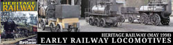
Below: Trains did run around from Rowley, though most of the images I’ve been able to find (with the exception of the Beamish Development Trust sortie with 876 and NER coach 818) are goods trains. Here is the J21 in what we now call the Francis Street Exchange Sidings. Notable is the lack of trees growing on the railway embankment, and the turnout in the foreground which remains today and access the Colliery sidings. The area to the left of the locomotive, in the middle distance, is now the occupied by Spainsfield Farm.

Below: This view, of rather indifferent quality, was possibly taken on the same occasion as the view above. It shows 876 negotiating the curve that we saw earlier in the photo of Coffee Pot. Pockerley Old Hall, then a working farm, is seen in the background. The undulating nature of the trackbed can clearly be seen both behind and in front of the train. This area is now the approximate location of the tram stop at Pockerley.

I am gathering a lot of information for a book on the railway collection and operations (and a future book on the Tramway/Bus operations here) – no timescale for publication of which has been determined. But I hope that it will put on record a great deal of history as Beamish itself approaches its sixtieth anniversary in 2030. Meanwhile, the title ‘Beamish – 40 years on Rails’ and available from Middleton Press does cover quite a lot of the timeline and I am sure will help answer many of the questions that I have seen appear on social media in recent months, with regard to the railways at the museum.


Absolutely fascinating. You can definitely see the rather ‘eccentric’ trackbed – it was struck me as incredible that Beamish effectively runs four different railway operations alongside such enormous machines like the colliery winding engine and the like.
I’m sure there’s a lot of interest in the idea of both Rowley and the Waggonway being extended from visitors. Is it something Beamish would ever pursue, especially with Dunrobin soon joining the fleet permanently? What sort of space is even available for that kind of extension?
Hi Jordan
There is certainly space to extend the operation at Rowley, but it is difficult terrain as would require extensive earthworks in order to reach the rear of the tram stop at Pockerley (the more obvious destination). It remains a one-day idea… The Colliery Railway, and Narrow Gauge, are land-locked and can’t really extend in length, but plans exist to expand the narrow gauge as and when we can find the time/resources, and improve the standard gauge line. The Waggonway could theoretically be extended by another 400 yards or so, but it would require a level crossing over a public right of way (for which we had to have an HMRI exemption for the wooden waggonway) and a lot of earth works, for very marginal gain really. But there is always opportunity to improve access and the visitor experience and these are the forefront of the plans for the next five years, at least, in terms of enhancing the collection of rolling stock/buildings, and making the infrastructure more resilient (not least to very warm and very wet weather). Best wishes, Paul
I worked at Beamish in Summer’78. Cars came in through ‘the lanes’ (E on the 1983 image) and paid for entrance tickets. When it was busy more lans were opened and we were sent out to sit in the little glass cabin, collect cash and issue tickets like at a toll booth. We did run ‘passenger’ trains with visitors in a children wagon, in those days behind the Locomotion replica. A staff member had to be in the chaldron to watch over visitors, I remember children wanting to sit on the wagon sides. There was no braking on the chaldron. That summer we had the launch of Lewin loco and opening of the pit village cottages.
Given the growth of the 1950s town possibility to create a post war station or something with a hint of the tyneside electrics ?